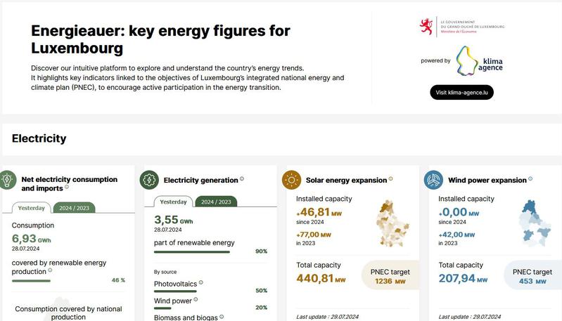
Charging stations for electric vehicles 2021

Updated on October 13, 2022 — Creative Commons Attribution 4.0

SIG-GR @ Ministère du Logement et de l'Aménagement du territoire - Département de l’aménagement du territoire

Système d'information géographique de la Grande Région.

339 datasets

1 reuses

Informations

License
Creative Commons Attribution 4.0
ID
60d1e0a6d5453a803c6c2014

Temporality

Frequency
Unknown
Creation date
June 22, 2021
Latest resource update
October 3, 2022

Geographic dimensions

Territorial coverage granularity
Grande region

Embed

Permalink

Description

Charging stations for electric vehicles in Luxembourg and within a radius of 40km from its borders (2021)

  • Sources: Bundesnetzagentur.de, Chargemap, Creos Luxembourg - Electro-mobility, DREAL Grand Est, LVGL Saarland, MWAEV Saarland, MWVLW Rheinland-Pfalz. Harmonization: SIG-GR / GIS-GR 2021

Files 4

Main file 2

charging-stations-for-electric-vehicles-2021-2046-charging-stations-electric-vehicles-40km-lux-0.geojson

Updated on June 22, 2021 — geojson (326.4Ko) — 4 downloads

charging-stations-for-electric-vehicles-2021-2046-charging-stations-electric-vehicles-40km-lux-0.shp.zip

Updated on June 22, 2021 — shp.zip (39.4Ko) — 2 downloads

API 2

Community resources 0

You have built a more comprehensive database than those presented here? This is the time to share it!

No resources match your search.

Reuses 1

Explore the reuses of this dataset.

Did you use this data ? Reference your work and increase your visibility.

Discussions 2

Discussion between the organization and the community about this dataset.

  • Charging point operator / Opérateur de la borne de rechargement

    Antoine le fur
    August 1, 2022

    Bonjour, Le fichier ne contient pas le nom de l’opérateur de la borne de rechargement, est-il possible de l’obtenir ? The file does not include the operator name of the charging point, is this normal and how to get it ? Merci !

  • Le lien WMS ne semble pas fonctionner.

    Arthur Van Marcke
    January 11, 2022

    Bonjour, j'essaie d'accéder à la version WMS de la carte "Bornes de recharge pour véhicules électriques 2021" mais il semble que le lien ne fonctionne pas correctement. Le message d'erreur est le suivant : This XML file does not appear to have any style information associated with it. The document tree is shown below. <ServiceExceptionReport version="1.3.0" xsi:schemaLocation="http://www.opengis.net/ogc http://schemas.opengis.net/wms/1.3.0/exceptions_1_3_0.xsd"> <ServiceException>unknown WMS request type 'None'</ServiceException> </ServiceExceptionReport>

    Thierry Hengen
    January 11, 2022

    Bonjour, This dataset is published in the view service (WMS) available at http://wms.gis-gr.eu/service?service=WMS&version=1.3.0&request=getCapabilities with layer name GR/Charging_stations_electric_vehicles_2021/Charging_stations_electric_vehicles_40km_LUX.

    Antoine le fur
    August 1, 2022

    Bonjour, Le fichier ne contient pas le nom de l'opérateur de la borne de rechargement, est-il possible de l'obtenir ? The file does not include the operator name of the charging point, is this normal and how to get it ? Merci !

    Thierry Hengen
    August 16, 2022

    Bonjour, Je vous conseille de vérifier les données originales et mises à jour: France et Belgique: https://fr.chargemap.com/map Luxembourg: https://data.public.lu/fr/datasets/bornes-de-chargement-publiques-pour-voitures-electriques/ Rhénanie-Palatinat: https://verkehr.rlp.de Sarre: https://geoportal.saarland.de/mapbender/frames/index.php?lang=de&gui_id=Geoportal-SL-2020&LAYER%5Bzoom%5D=1&LAYER%5Bvisible%5D=1&LAYER%5Bquerylayer%5D=1&LAYER%5Bid%5D=39497